Satellite Image Map for ATS (in-game map with satellite imagery) for American Truck Simulator
Replaces the white background of the ATS map with a satellite terrain image with borders, hand-fitted by Keeper1st over the SCS map. 9.39 MB, no DLC; last updated for 1.50 (September 8, 2024).
Download Satellite Image Map for ATS (in-game map with satellite imagery)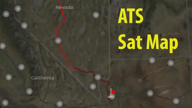
Official screenshots by the author: © Keeper1st on Steam WorkshopMore screenshots on steamcommunity.com (Steam Workshop) ↗
What this mod does
Satellite Image Map for ATS, by Keeper1st, is a texture pack that changes the in-game map: instead of the white background with borders, you see a satellite image of the terrain with the borders on top. The author says he spent hours warping the image so the U.S. borders would line up with the SCS map; outside the United States he took less care, though he says the result is good.
Limitations the author acknowledges
The curve between California and Nevada doesn’t match because the SCS map has it shifted; some roads in Southern California seem to run into the Pacific and the Lake Tahoe loop near Carson City ends up far from the lake. In the freight market view the zoomed-out image is more transparent so routes, cities and states stay readable, which is why the terrain looks darker when you zoom out. Mexico and Canada map mods use a different orientation: some users built their own mapdata files to fit them.
Version
The September 8, 2024 change note adapts it to the new texture handling of 1.50; in the comments the author says it needs no further updates, though he warns that a map redesign with British Columbia could break it. It weighs 9.39 MB, needs no DLC and has 51,057 subscribers since November 2017. More graphics mods for ATS.
Holyfix Check
Will it work with your mods?
Load your game.log.txt and check whether this mod is for your ATS version, whether you're missing a mod or DLC it needs and where to place it.
It's in Documents › American Truck Simulator › game.log.txt. It's read in your browser: the file is never uploaded.
Something else failing? Holyfix for ATS checks all your mods at once.
User rating
Highlights and things to keep in mind
- In-game map with real terrain instead of the white background
- Very light (9.39 MB), free and no DLC
- Over 51,000 subscribers and 793 five-star ratings
- Latest game version confirmed by the author: 1.50. It may throw errors on the current version; Holyfix will warn you if so
- Acknowledged misalignments: California-Nevada curve, Southern California roads and Lake Tahoe
- With Mexico, Canada, Alaska, C2C or DNA map mods the background may be shifted
- The author warns a map redesign with British Columbia could break it and that he can't redo the adjustments
- The author doesn't state the source of the satellite image he adjusted
Requirements
- American Truck Simulator 1.50 or later
- Steam account to subscribe on the Workshop
- No DLC needed; the map covers the whole United States and the states you own look the same
How to install it
- Open the Satellite Image Map for ATS page on the Steam Workshop and hit Subscribe
- Wait for Steam to finish the download (9.39 MB)
- Open ATS, go to the Mod Manager and enable the mod
- Open the in-game map (M key): the white background is replaced by the satellite image; it looks darker when zoomed out on purpose
Version history
-
—8 Sep 2024Current
Updated to work with changes to how ATS mods handle textures in 1.50
-
—16 Nov 2017
Posted on the Steam Workshop
Common problems
Which ATS version is it for?
The latest update, from September 8, 2024, adapts it to the 1.50 texture changes. The author says in the comments it needs no further updates.
Why don't some roads match the terrain?
The author blames the SCS map: the California-Nevada curve is shifted and some cities, such as Santa Cruz, aren't in their real spot.
Does it work with Mexico or Canada maps?
The author says those mods use a different orientation; some users built their own mapdata files to fit them.
Why does the terrain look dark when I zoom out?
It's intentional: in the freight market view the image is more transparent so routes, cities and states stay readable.
Where are the state names?
The game engine draws them, not the mod; they show in the overview map.
More mods for ATS
 ATS 1.59
 ATS 1.61
 ATS 1.59
 ATS 1.61
 ATS 1.60
 ATS 1.61